PHOTO
By JOHN TAYLOR OAM, Myrtleford and District Historical Society Inc.
UNTIL the building of permanent structures across streams, there were recognised "crossing places" or "fords" to convey people and possessions across waterways.
The First Peoples had used them for centuries, and early exploration parties found and named them.
From the late 1830s, early occupiers of pastoral runs, then gold miners in the 1850s, chose these shallow crossings or felled logs across streams to expedite traffic.
It was not until the creation of local roads boards from 1862 that bridge building began, using local timbers produced with the axe or at bush mills.
By the early 1880s railway bridges of timber were being built too, to accommodate the Ovens Valley Railway at Bowmans and at Gapsted, Myrtleford, Ovens Vale and Rostrevor.
Two would be strengthened with brick embankments to prevent washaways. It was not until 1944 that a major upgrade to all rail bridges would finally occur.
The long wait for bridge builders caused farming communities to build swing bridges across streams to facilitate communication and transport between families and meet their needs in medical emergencies.
Some of these crossings became the subject of postcards because of their picturesque settings.
On the Ovens, swing bridges spanned the river from Harrietville to Rocky Point and beyond and across nearby tributaries.
Crossings of the Ovens were cause for celebration:
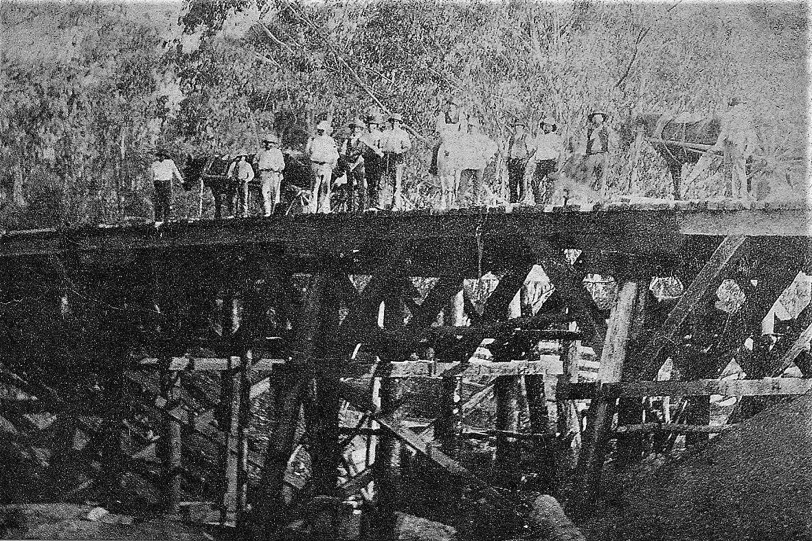
The "Nimmo Bridge" was constructed by a work gang led by Denis Toner.
It was officially named in honour of Mr. J. Nimmo, who was Minister for Public Works from 1886––89.
The foundations of this bridge are still seen in the waters downstream of the current bridge, at Apex Park.
A second timber bridge was then built but replaced by concrete and steel in 1964–65 when a road realignment and strengthening was required for transporting materials and equipment to the Buffalo Dam construction site.
At Wobonga, a crowd attended the opening of a swing bridge in the 1890s, the first crossing of the Ovens of this type at Eurobin, where today's modern Wobonga Lane Bridge exists.
The "Rocky Point Bridge" was opened on November 5, 1908 after protracted negotiations over funding between the Oxley Shire and United Shire of Beechworth.
Canvassing of Whorouly and Myrtleford residents also added funds to an amount contributed by the Victorian Government.
Hon. A.A. Bilson, MLA opened the bridge and Miss Alice Walpole cut a red, white & blue ribbon in front of a crowd of 1,000.
A festive atmosphere prevailed, the bridge being described as "a triumph of the times".
A new bridge would replace it in 1936, followed by another structure downstream on a realigned roadway in 1989.
All bridges come under pressure in flood times.
The impact, if the two floods of 1917 are examined, was particularly noteworthy with consequences for all Ovens River crossings and tributaries.
Some quotations from the pages of the 'Myrtleford Mail' in June and October, 1917 reveal the impact:
At Myrtleford: "The approaches on both ends of the Victoria Bridge have been washed away.
"The footbridge crossing the creek near Frauenfelder's Hotel is still standing, though in a dilapidated condition.
"Nimmo Bridge has stood the strain remarkably well, and is quite secure, though the approaches are a source of anxiety."
At Happy Valley and Mudgegonga: "On the Happy Valley–Barwidgee Road, the bridge over Happy Valley Creek is broken down.
"At Mudgegonga, the Sandy Creek Bridge requires attention.
"The bed of the creek has been considerably cut out and the piles may be undermined."
At Whorouly: "The Rocky Point Bridge is some feet out of line in the centre.
"The debris packed up against the bridge, forcing the water to flow down the main road, flooding land not usually flooded."
At Eurobin and beyond: "The railing has been washed away from Wobonga Bridge, but it has stood the strain well.
"At Porepunkah, the new concrete bridge went before the force of the flood.
'The approaches have also gone.
"Another bridge, at Morse's Creek in Bright, is in danger.
"At Germantown, on the main road to Harrietville, another timber bridge has been completely wrecked.
"Towards Wandiligong, the bridge at Dougherty's Crossing is impassable."
Today, we appreciate the strength of our road bridges, and the gauging stations at the site of the original Wobonga and Rocky Point crossing places provide significant information for residents of the Ovens Valley.